Wildlife and habitats
Turn sightings into evidence.
Photograph wildlife, plants, ponds, hedgerows, mature trees and habitat routes. Record the date, time and exact location or map pin. Do not disturb wildlife or enter private land.
Green Not Greed · Protect Lightwood's Green Belt
Stoke-on-Trent Local Plan · Site BL1
The council proposes its single largest housing allocation: 113.19 hectares of Green Belt land between Lightwood, Cocknage, Rough Close and Meir Heath.
Thank you to everyone who submitted a representation by 14 September 2026.
Lightwood Community Group · Submitted 13 September 2026
Lightwood Community Group has formally submitted its consolidated Regulation 19 representation. It asks for Allocation BL1 to be deleted from the Local Plan and the land to remain within the Green Belt.
Full representation · PDF · 20 pages
Evidence schedule · XLSX
Nine supporting files were sent to the Council with the main representation and matrix.
The consultation has closed, but the evidence still matters
The proposed site stretches between Lightwood Road, Cocknage Road and Woodpark Lane—open land separating several existing neighbourhoods.
The map below is taken from the council's 2026 Landscape Sensitivity Assessment. It shows the extent of Site BL1 in red.
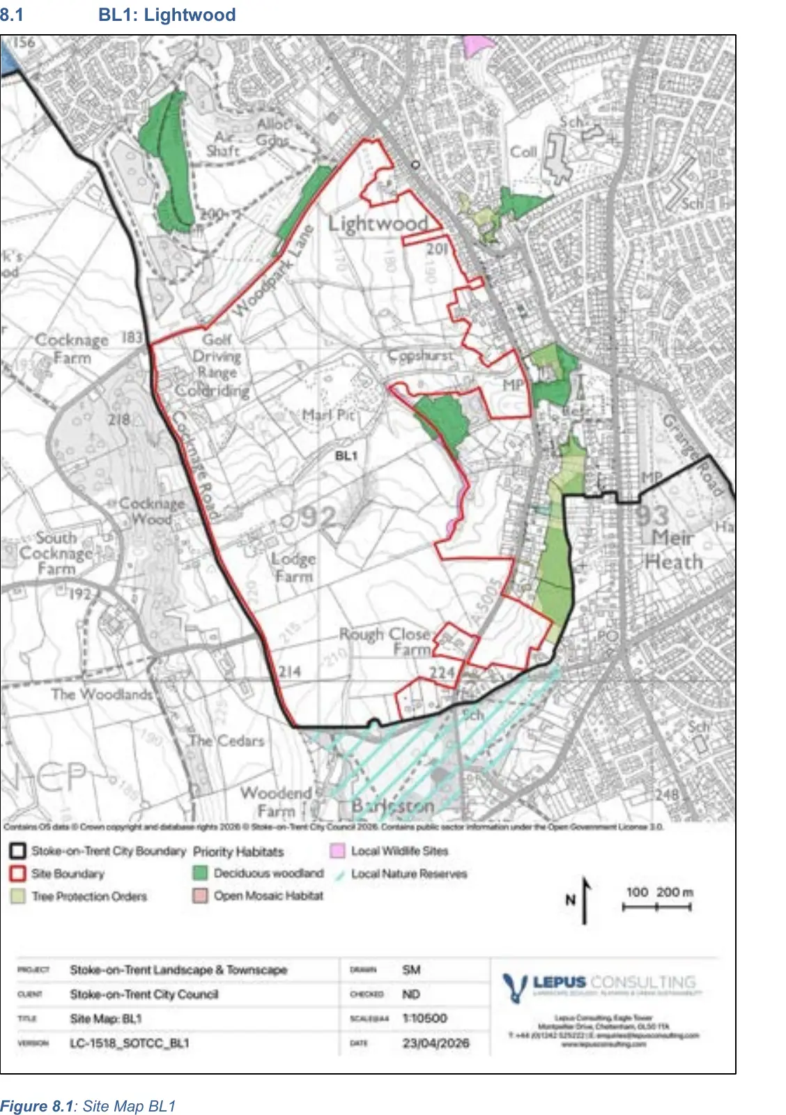
Source: Stoke-on-Trent City Council Landscape Sensitivity Assessment, June 2026, Figure 8.1. View the source document ↗
These council map exports show the Mineral Safeguarding Area and recorded archaeological sites across and around the land proposed for BL1.
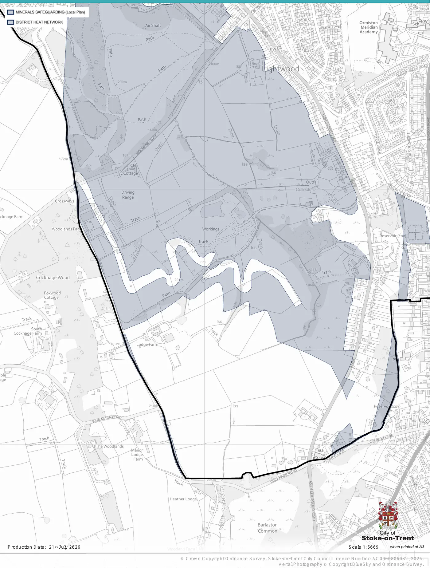
Mineral safeguarding
The council needs to explain how development would avoid unnecessarily sterilising safeguarded mineral resources, or why development should take priority.
View the full council map ↗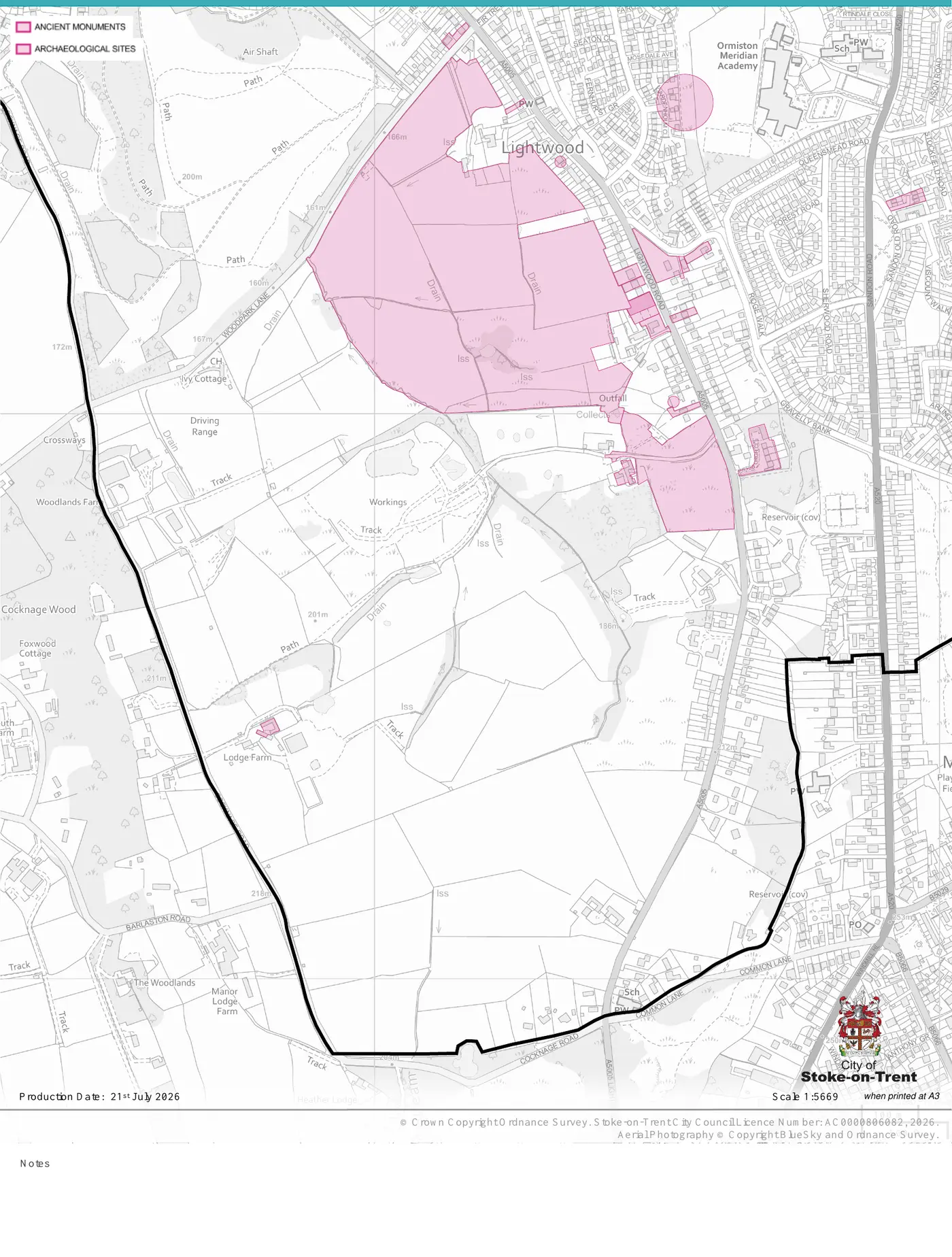
Archaeology
The archaeological interest of the land must be properly assessed before allocation, with the significance of any affected remains understood and protected.
View the full council map ↗Source: Stoke-on-Trent City Council map exports, produced 21 July 2026. Crown Copyright Ordnance Survey.
The headline is 3,000 homes. These figures show what that could mean in land, population and density.
The total BL1 allocation shown in the Regulation 19 material.
The gross density across the allocation—one of the highest in the plan.
An indicative population using 2.4 residents per household.
Indicative dependent children—not the same as required school places.
For comparison
At Census 2021, Blythe Bridge and Forsbrook had 2,949 households and 6,798 residents. BL1 proposes 3,000 homes and could accommodate around 7,200 people.
Housing target context
The Government's December 2024 indicative local housing-need figure for Stoke-on-Trent rose by 35.4%. The question is not whether homes are needed, but whether BL1 is the right location and scale.
Figures and full sources are set out in the Lightwood Community Group public meeting presentation.
BL1 is not just a line on a map. Think about the roads you use, where your children go to school, the services your family relies on and the landscape you see every day.
More homes mean more journeys. What could that mean for Lightwood Road, Cocknage Road and the routes you already use for work, school and everyday life?
A development of this size would bring thousands of new residents. Local school places, GP services and other facilities must be planned for properly—not promised later.
The fields, hedgerows, lanes and wildlife between our communities are part of daily life here. Once developed, that open landscape cannot be put back.
This would not appear overnight. Families closest to the site could face years of construction traffic, noise, dust and changing access routes.
Transport
Schools and health
Water and utilities
These are indicative estimates based on Census 2021, Department for Transport, Department for Education and NHS England averages—not site-specific forecasts. Actual demand would depend on housing mix, occupancy and resident demographics.
GREEN NOT GREED
A campaign by Lightwood Community Group
We are raising funds to support the community campaign against plans for 3,000 homes on Lightwood's Green Belt. Every contribution helps us gather evidence, reach residents and challenge BL1 properly.
Donate to the campaign ↗Our objection is about whether this is the right place for development on this enormous scale—and whether the evidence really supports the council's choice.
BL1 would remove a very large area of open land from the Green Belt and change the countryside separating established communities.
The effects would cross council boundaries. Routes towards the A50, A34, M6, Barlaston and surrounding communities must be tested against limited local public transport and no immediate rail link.
Thousands of new residents would need school places, healthcare, drainage, water, power and other services. Where will that capacity come from?
Fields, hedgerows, trees and linked habitats work together. They must be understood as a living landscape, not treated as separate features on a plan.
Historic lanes, listed buildings, the rural setting and the area’s archaeological potential all need proper investigation and protection.
BL1 is within a Mineral Safeguarding Area. The plan must properly address the mineral resource and the risk of permanently sterilising it through development.
Before Green Belt is lost, the council must show that realistic alternatives—including vacant, derelict and underused land—have been properly considered.